Transportation Safety Board of Canada – Link
Reproduction of this publication is meant solely for educational purpose to help prevent accidents and inform the public and Pilots.
Background
The privately owned Cessna 170B (registration N4512C, serial number 25456) was being flown on a ferry flight from Flying Cloud Airport (KFCM), Eden Prairie, Minnesota, United States (U.S.), to Ted Stevens Anchorage International Airport (PANC), Anchorage, Alaska, U.S. On board were the new owner of the aircraft, who had recently purchased it, and a second pilot. They were both commercial pilots and were taking turns performing the role of pilot flying. The new owner of the aircraft was also using this ferry flight to meet the requirements to obtain a tailwheel endorsement in accordance with the U.S. Federal Aviation Administration’s regulations.Footnote1 The second pilot was a certified flight instructor who was able to authorize the endorsement.
On 23 May 2019, after working a full day, the second pilot travelled overnight from PANC to Minneapolis-St Paul International/Wold-Chamberlain Airport (KMSP), Minnesota, U.S., where the new owner picked him up on 24 May 2019. The 2 pilots then travelled together to KFCM.
After being delayed due to weather for the better part of the day, the aircraft was loaded with the gear they intended to transfer to PANC. The aircraft then taxied to the runway. During takeoff, controllability issues were encountered, and the takeoff was rejected. The investigation was unable to determine the nature of the controllability issues.
The aircraft taxied back to the hangar, and the gear was unloaded. The 2 pilots completed 3 circuits at KFCM in the empty aircraft. Once they had landed, approximately half of the gear was reloaded. The rest of the gear was left behind to be sent to Alaska by other means. It was then decided to delay the departure until the next day.
On 25 May 2019, the day’s flight began at KFCM and ended at Coutts/Ross International Airport (CEP4), Alberta. The pilots made 4 stops along the way. The operational day was 14 hours long.
On 26 May 2019, the flight continued across Alberta and ended at Fort St. John Airport (CYXJ), British Columbia (BC). The pilots made 2 stops along the way. The operational day was at least 12 hours long.
History of the flight
On 27 May 2019, the aircraft departed CYXJ and, after stopping at Fort Nelson Airport (CYYE), BC, and Watson Lake Airport (CYQH), Yukon, for fuel, the aircraft landed at Whitehorse/Erik Nielsen International Airport (CYXY), Yukon. By the time the pilots reached CYXY, they had been travelling for at least 11 hours. The investigation determined that the pilots had intended to continue on to PANC that day.
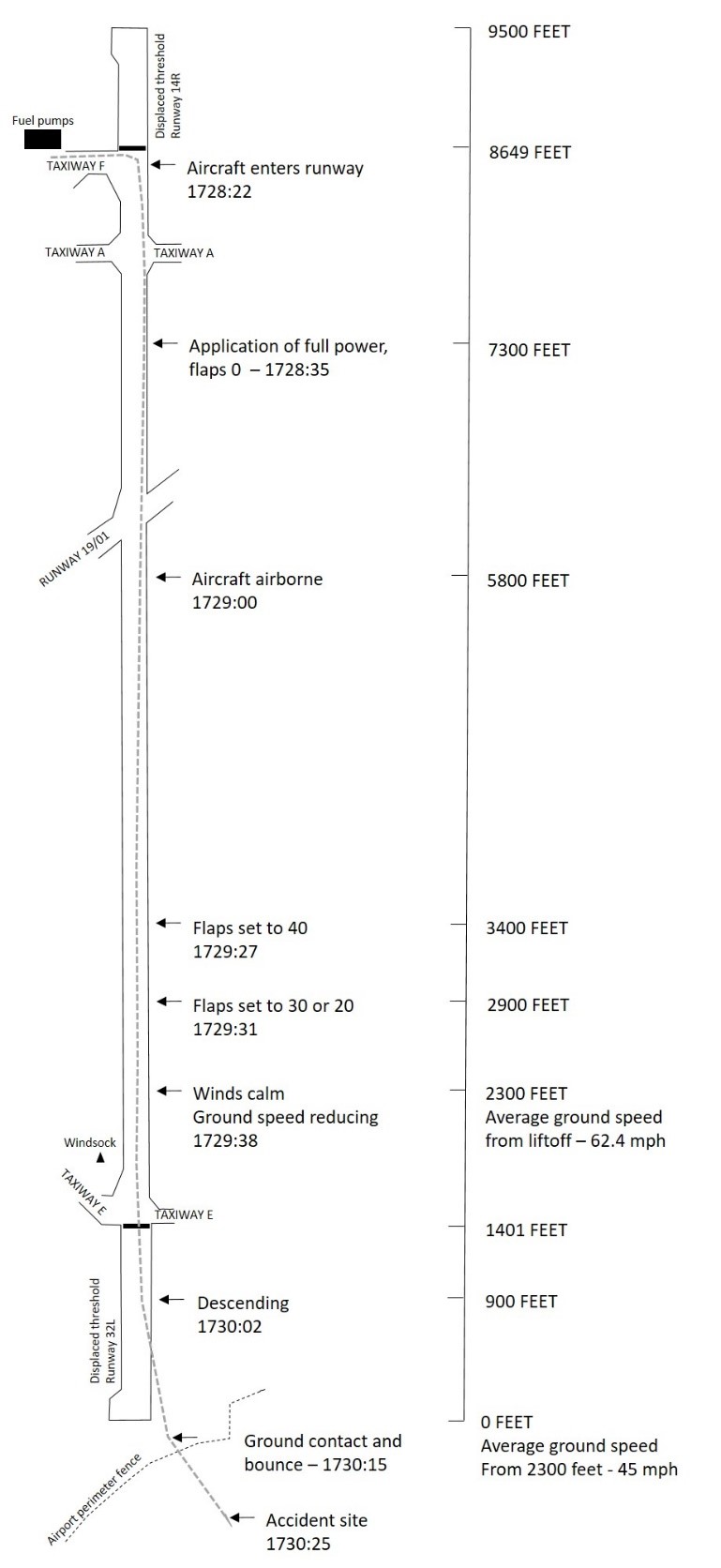
At approximately 1720,Footnote2 after the aircraft was refuelled and the flight plan was filed, the second pilot, who was the pilot flying and was seated in the left seat, taxied along Taxiway F to Runway 14R (Figure 1).
Before departure, the pilot flying discussed the variability of the wind speed and direction with the tower controller. The tower controller indicated that the winds at the end of runway where the take-off run would be initiated were 210° magnetic (M) at 15 knots, gusting to 20 knots. The windsock at the other end of the runway indicated that the winds were calm.
After entering Runway 14R from Taxiway F, the pilot flying taxied down the runwayFootnote3 and positioned the aircraft for takeoff on the very left side of the runway, approximately 2200 feet down the runway. He then steered the aircraft diagonally to the right to allow for a more into-wind take-off run.
At 1728, when the aircraft was cleared for takeoff, the winds were still 210°M at 15 knots, gusting to 20 knots. The pilot flying started the take-off run with 7300 feet of runway remaining.
The aircraft became airborne with 5800 feet of runway remaining. The pilot flying put the aircraft into a right-wing-low attitude, which was maintained in varying degrees throughout the takeoff, and the aircraft climbed slowly.
With 3400 feet of runway remaining, the pilot flying lowered the flaps from 0° to 40°. With 2900 feet of runway remaining, the pilot reduced the flap setting to either 30° or 20° where they remained; the exact setting could not be determined. With 2300 feet of runway remaining, the aircraft entered the area of calm wind as indicated by the limp windsock (Figure 2).
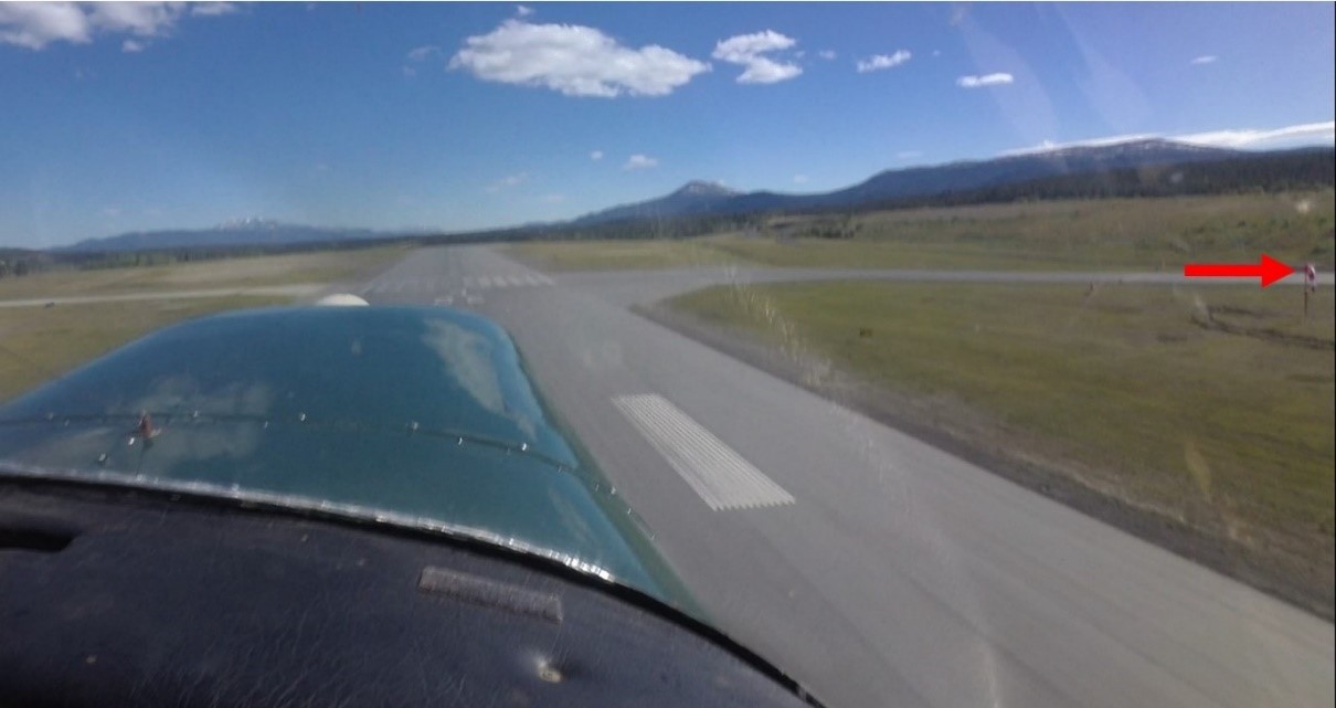
With 900 feet of runway remaining, after reaching approximately 50 feet above the runway surface, the aircraft began an uncommanded descent.
At 1730:15, when the aircraft was approximately 150 feet beyond the end of the runway, it struck the ground near the perimeter road, bounced, and cleared the airport fence, beyond which is a 120-foot drop-off. When the aircraft was just past the fence, its stall warning horn sounded. The aircraft stalled, and the left wing dropped. There was a very brief recovery and the stall warning horn ceased; however, the recovery was quickly followed by a secondary stall, and the aircraft rolled abruptly to the right and departed controlled flight.
At 1730:25, the aircraft crashed into a wooded area and was severely damaged. An on-board video recorder continued to record both audio and video after the aircraft came to rest. Based on the audio, electric power was still on after the crash because a beeping sound could be heard. A fire erupted 10 seconds after impact and eventually consumed the aircraft. Both occupants were fatally injured. The emergency locator transmitter activated during the crash sequence.
Weather information
The hourly aerodrome routine meteorological report (METAR) for CYXY at 1700 was as follows:
- wind 200° true (T) at 12 knots, gusting to 19 knots
- visibility 40 statute miles
- few clouds at 8000 feet above ground level (AGL)
- few clouds at 13 000 feet AGL
- temperature 24 °C
- dew point 4 °C
Aircraft information
The 1952 Cessna 170B is an all-metal, 4-seat aircraft with conventional landing gear. The flaps can be set to 0°, 20° (1st notch), 30° (2nd notch), and 40° (3rd notch). The aircraft was powered by a Continental C145-2 reciprocating engine.
The last 100-hour inspection carried out on the engine was completed on 07 August 2018. A pre-purchase inspection was completed on 05 May 2019, and the letter from the inspecting technician indicated that the compression on all cylinders was at or above 72/80 psi,Footnote4 which was consistent with the 100-hour inspection performed in 2018.
Records indicate that the aircraft was certified, equipped and maintained in accordance with existing regulations and approved procedures.
Pilot information
The pilot flying on the occurrence flight held a U.S. commercial pilot certificateFootnote5 with the following ratings: single-engine land, single-engine sea, and airplane instrument. He also held a flight instructor rating. His pilot logbook was destroyed in the post-impact fire; however, the investigation was able to determine that up to April 2019, he had accumulated 9563 hours total flight time. Training records from his employer showed that he had experience on Cessna 185 aircraft, on Cessna 206 aircraft, and on de Havilland DHC-2 Beaver aircraft on floats, skis and wheels.
The new owner of the aircraft was an ex-military helicopter pilot who held a U.S. commercial pilot certificate with the following ratings: airplane single-engine land, rotorcraft – helicopter, and airplane and helicopter instrument. He had accumulated approximately 1400 hours total flight time. Of those 1400 hours, 1240 hours were on helicopters and 160 hours were on single-engine fixed-wing aircraft.
Airport information
NAV CANADA’s Local Area Weather Manual describes CYXY as being “located just to the west of the city on a level plateau approximately 225 feet above and parallel to the Yukon River.”Footnote6 The airport is at an elevation of 2317 feet above sea level (ASL) and is surrounded by mountains “reaching heights of over 6,000 feet ASL at 15 nautical miles to the southwest, 7 miles to the east, and 30 miles to the northwest of the airport.”Footnote7 The airport frequently experiences wind that is created by a combination of valley effects and regional pressure gradients: more specifically, “[…] strong overriding west to southwest winds aloft will generate more significant and widespread turbulence with directional shear appearing within a thousand feet of surrounding mountain top elevations.”Footnote8
Wreckage information
Although the post-impact fire had consumed the entire aircraft, the investigation was able to retrieve some documents and a video recorder from the wreckage. The video recorder was sent to the TSB Engineering Laboratory in Ottawa, Ontario, for examination and analysis.
A cursory inspection of the engine was carried out at the accident site and compression in the cylinders was confirmed. Due to the impact damage and the post impact fire, the investigation could not conclusively identify any issue that would have prevented the engine from producing full power.
Inspection of the airframe to determine flight control continuity was not possible due to fire damage; however, video retrieved of the occurrence flight showed the aircraft responding to flight control inputs.
Aircraft performance
The video camera on board the aircraft recorded both the takeoff from CYQH and the occurrence takeoff. The TSB Engineering Laboratory separated the audio file from the video file and compared the propeller speeds for both takeoffs. On both flights, the static propeller speedsFootnote9 were observed to peak short of the full throttle rpm check rangeFootnote10 of 2230 to 2330 rpm indicated in the Cessna 170B owner’s manual. During both takeoffs, there was a gradual acceleration of propeller rpm as the aircraft speed increased. The maximum propeller speed observed during the departure from CYQH was 2360 rpm. The maximum propeller speed for the occurrence takeoff varied from 2230 to 2241 rpm.
Due to the extent of the post-impact fire, the investigation could not determine the aircraft’s precise take-off weight on the occurrence flight; however, based on information collected, it is likely that the aircraft was at least at the gross take-off weight of 2200 pounds.
The density altitude at the time of departure was calculated to be 4069 feet ASL with a headwind component of 5 knots at the beginning of the take-off run.
The Cessna 170B performance chartFootnote11 indicates that the take-off distance required at CYXY with a temperature of 24 °C (80 °F) and with flaps up would be 936 feet to become airborne and 2340 feet to clear a 50-foot obstacle. The Cessna 170B performance chart also indicates that, at a gross weight of 2200 pounds and with flaps up, the aircraft should have achieved a climb rate of 580 feet per minute. From the time full power was applied, the aircraft used about 1600 feet to become airborne and never climbed above 50 feet during the entire takeoff.
As explained in the Cessna 170B owner’s manual, “[t]he flaps supply added lift and considerable drag […].”Footnote12 The manual also states that “[t]he use of flaps is not recommended for cross-wind take-offs.”Footnote13
The manual states the following with respect to using flaps at higher density altitudes:
[…] as altitudes and outside air temperatures increase, drag off-sets lift until eventually the use of flaps increase the take-off distance. It is recommended that the take-off chart […] be consulted to determine whether the use of flaps is desirable for take-off. […] 30 and 40 degree flaps are not recommended at any time for take-off.
REMEMBER
Don’t, under marginal conditions, leave flaps on long enough that you are losing both climb and airspeed.Footnote14
The Cessna 170B performance chartFootnote15 indicates that landing performance at CYXY at approximately 24 °C (80 °F) using 40° of flap requires 1245 feet total to land over a 50-foot obstacle. Of that distance, 747 feet is in the air, and the remaining 498 feet is the rollout after landing. In this occurrence, the distance available from the point at which the descent started to the perimeter fence was about 1000 feet.
Safety messages
In this occurrence, after becoming airborne, the aircraft did not climb above 50 feet, and a right-wing-low attitude was maintained on the departure climb. As well, the flaps were set to 40° and then to either 30° or 20°, which would have increased drag. The Cessna 170B owner’s manual clearly states that the use of flaps at higher density altitudes is not recommended. It is important to follow aircraft manufacturers’ recommendations to ensure the aircraft performs as designed.
In addition, the investigation was unable to determine why the takeoff was continued through a performance-decreasing wind after the aircraft was unable to climb. If the aircraft is not performing as expected during takeoff and there is sufficient runway remaining to bring the aircraft to a stop, pilots should consider discontinuing the takeoff.
This report concludes the Transportation Safety Board of Canada’s investigation into this occurrence. The Board authorized the release of this report on 11 December 2019. It was officially released on 16 December 2019.

